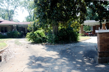
616 Logansport Photographs
616 Logansport 2011 Summer Survey
Starting in 1929 and continuing through 1946, Sanborn Company fire insurance maps show a stable near the rear of the 616 Logansport, property. Satellite imagery available from Google Maps show this structure is no longer present. The Sanborn maps also show a detached garage at the rear of each Sisters' property. While not visible from the street, Google Maps satellite photos show both garages still in existence. In order to allow easier access to the house, current owners have re-purposed the original attached carriageway as a carport. (1922 Sheet 6; 1929 Sheet 8; 1946 Sheet 8).Significance: The date of Jennie Hoya's marriage to L B Mast remains elusive. Census data from 1910 shows Jennie Hoya as a unmarried woman living with her parents. Local records show her sister, Clara Hoya, married Roy Gray in 1914. Most likely, both buildings were intended as wedding gifts to his daughters by Charles Hoya.
Links:
|
Sanborn Company Map- 1922 Sheet 6 |
http://www.lib.utexas.edu/maps/sanborn/m-o/txu-sanborn-nacogdoches-1922-6.jpg |
|
Sanborn Company Map- 1929 Sheet 8 |
http://sanborn.umi.com/image/view?state=tx&reelid=reel28&lcid=8670&imagename=00054&mapname=Nacogdoches%20Mar.%201929,%20Sheet%208&CCSI=894n |
|
Sanborn Company Map- 1946 Sheet 8 |
http://sanborn.umi.com/image/view?state=tx&reelid=reel28&lcid=8670&imagename=00066&mapname=Nacogdoches%20Mar.%201929-Aug.%201946,%20Sheet%208&CCSI=894n |
|
Photograph of Clara and Jennie Hoya |
http://digital.sfasu.edu/u?/Stern-Hoya,96 |
616 Logansport 1990 National Register Information
- Address: 616 Logansport
- Date: 1914
- Category: Contributing
- Block: 41
- Lot: 8
- Description: 1-story; wood frame construction with brick veneer; brick foundation; irregular plan; low hipped roofs with gabled dormers (south and west) and porte cochere (north), deep overhang, extended rafter ends; porch across front and a portion of north and south sides, strong horizontal emphasis with deep overhangs and full porch, short posts rest on large brick piers with pointed concrete caps, sides of piers flare into the brick pier and wood railing, with wooden elements and pier caps painted a contrasting white; porch is symmetrical with a central entry; the entry is flanked brick chamfered bays; windows are wood double-hung with diamond panes in the upper sash; entry door is wood with three rectangular lights, flanked by side lights with 2 slender beveled glass lights; dormers on south and west have extended rafter and beam ends, vertical wood siding, small diamond-paned windows; secondary entries on south and northwest comers; brick chimneys on north and south; sunporch on north with diamond-paned casement windows; porte cochere on north echoes detailing at the porches; detached brick veneer over frame garage with hipped roof with Spanish tile. Property is surrounded by a low brick wall with piers with concrete coping similar to the porch; 616 is very similar to 620, and they share an entry drive which splits and continues to each porte cochere.
- Significance: Designed by master architect Dietrich Rulfs, Charles Hoya built this house in 1914 for his daughter Jennie Hoya Mast. She was married to L. B. Mast. This brick single story structure is a twin to 620 Logansport which belonged to her sister, Clara Hoya.
616 Logansport 1986 Survey Information
- Address: 616 Logansport
- Name: Jennie Hoya Mast House
- Date: 1914
- Block: 41
- Lot: 8
- Condition: Excellent
- Description: 1-story; wood frame construction with brick veneer; brick foundation; irregular plan; low hipped roofs with gable dormers (south and west) and porte cochere (north), deep overhang, extended rafter ends; porch across front and a portion of north and south sides, strong horizontal emphasis with deep overhangs and full porch, short posts rest on large brick piers with pointed concrete caps, sides of piers flare into the brick pier and wood railing, with wooden elements and pier caps painted a contrasting white; porch is symmetrical with a central entry; the entry is flanked brick chamfered bays; windows are wood double-hung with diamond panes in the upper sash; entry door is wood with three rectangular lights, flanked by side lights with 2 slender beveled glass lights; dormers on south and west have extended rafter and beam ends, vertical wood siding. small diamond-paned windows; secondary entries on south and nonhwest corners; brick chimneys on north and south; sunporch on north with diamond-paned casement windows; porte cochere on north echoes detailing at the porches; detached brick veneer over frame garage with hipped roof with Spanish tile. Property is surrounded by a low brick wall with piers with concrete coping similar to the porch; 616 is very similar to 620, and they share an entry drive which splits and continues to each porte cochere.
- Significance: Architectural. One of the twin residences built for the Hoya sisters by their parents.
.JPG)
.JPG)
.JPG)
.JPG)
